|

|
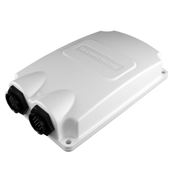
MT 3000 Marine Unit
The MT3000 provides satellite-based data communication capabilities for
machine-to-machine (M2M) applications. The MT3000’s rugged enclosure,
discrete size and flexible configuration makes it versatile enough to
suit a wide range of tracking and monitoring applications.
|
|
The Marine unit is a complete remote monitoring and communications solution. It offers operators huge competitive advantages in increased operating efficiency as a result of cost saving, increased equipment uptime and emergency communication. The Marine unit comes with an easily installable and user configurable software package with the option of displaying information on any computer with a unique password.
Remote water borne assets, such as fishing vessels, passenger ships and container/cargo vessels can be remotely monitored on a regular basis via the receipt of regular reports through the Internet. Users can also receive regular reports and alarms via preferred means, including fax, e-mail and phone/cell phone. This will provide both the operator and owners with real time positional data and vital information on their asset as well as text communication with vessel anywhere on the Oceans, Lakes and Rivers.
Information available to the user includes current and historical data, speed, temperature and location displaying co-ordinates (Latitude/Longitude) of the remote asset. The system can also be interfaced to remote assets systems to allow the remote user to become aware of incorrect operation of the asset or impending failures.
Users are able to view information and operate the system from the office via an Internet connected computer connected to the Marine unit and are also alerted to unscheduled events, receiving alarms for events including sudden temperature changes, traveling outside of specified boundaries (geo-fencing) and remote emergency (panic button).
|
| |
|
|
FEATURES
|
|
On-Board Computer/Processor - Create custom applications and local logic to reduce time-to-market for tailored solutions.
Sensor Ports (Digital and Analog I/Os) - Monitor and control local sensors and devices, detect power failures or report when machinery is activated.
Low Power Consumption - Count on several years of service with a single battery when asset power is not available.
Two-Way Communication - Report data by schedule or events, request instant GPS location, monitor status of local sensors or change device reporting intervals.
Low Message Latency - Enjoy immediate communication to and from the asset. No long delays.
Geofencing Capabilities - Identify areas of interest and program special reporting intervals based on location.
Low Profile and Inconspicuous Appearance - Provide covert installation easily.
Over-the-Air Programming Capability - Make quick and easy terminal configuration changes according to shifting business needs, reduce downtime and minimize travel and labor costs.
Customizable and Easy Programming Interface - Get to market faster and create unique solutions.
Use of Geosynchronous Satellite Constellation - Provide reliable, secure, real-time satellite communication.
|
| |
|
SPECIFICATIONS
|
|
| PHYSICAL |
EXTERNAL INTERFACES |
| Size |
17.6 cm x 10.8 cm x 4.0 cm |
Serial:
- 2 ports compatible with RS-232 and RS-562 8rla - 1 port RS-485, J1708
Digital:
- 4 network inputs/outputs Digital - 5 application inputs - 3 application input/outputs - 2 high current digital output: 0.5A combined.
Analog:
- 2 network analog inputs: 0-3 Volts Analog - 2 application extended analog inputs: 0-3 Volts or 033 Volts.
|
| Mass |
< 500 grams |
| ENVIRONMENTAL |
| Operating Temperature |
-40°C to +85°C |
| Storage Temperature |
-55°C to +85°C |
| Humidity |
Meets SAE J1455 |
| Dust& Water Ingress |
Meets SAE J1455 |
| Vibration |
Meets SAE J1455 |
| Shock (survival) |
Meets SAE J1455 |
| ELECTRICAL |
|
| Power |
Direct vehicle connection (load dump protected) External lithium battery
pack options: . Over 5-year life @ 2 reports/day Other battery packs
available |
| Input Voltage Range |
8V to 32V (vehicle input) |
|
| 4.5V to 32V (battery input) |
|
| Power Consumption (Typical ©7.2VDC) |
Idle mode: <439 |jW Transmit mode: < 14 W Receive mode: <626 mW GPS power consumption: <756 mW |
| SATELLITE COMMUNICATIONS |
|
| Frequency |
1626.6-1660.5 MHz (From-Terminal) 1525-1559 MHz (To-Terminal) |
| Elevation Angle |
20° to 90° for communications link 10° to 90° for GPS |
|
SATELLITE MESSAGING
From-Terminal 11 bytes, 350 bps
To-Terminal Up to 38 bytes, 1200 bps
|
PROGRAMMING CAPABILITIES
Reporting:
- Polls for GPS location
- Optional pre-scheduled, configurable over-the-air, reports every 10 minutes to 24 hours
- Events-based upon exceeding user-defined parameters
- User defined data reports
|
| GPS |
ADDITIONAL FEATURES
|
| Acquisition |
Cold: <40 seconds; Warm: <16 seconds |
Sensor: Integrated start/stop sensor |
| Accuracy |
11 meters, 95% of the time |
ORDERING CODES |
| CERTIFICATIONS / COMPLIANCE |
6100104-XX - MT3000 sensor-enabled terminal with on-board application processor |
| Satellite |
Inmarsat Type Approval |
6100104-XX - C1D2 classified MT3000 sensor-enabled terminal with on-board application processor
|
| Regulatory |
UL 1604, Class 1, Division 2 Groups A, B, C, D; T6 (6100097 only)
|
| APPLICATIONS RESOURCES |
|
| Processor |
Atmel ATMega2560 |
|
| Program Flash |
144kB |
|
| Internal EEPROM |
2kB |
|
| External SRAM |
16 kB direct plus 13 switchable banks of 16 kB |
| External Data Flash |
2 MB |
|
| Other |
Propriety pre-emptive and priority Simple embedded file system Custom API |
|
| |
|
|
top
back to IsatM2M
back to DNS Overview
|
| |
|
| |
|
|
|
|
|